


In today’s competitive real estate market, high-quality visuals are essential for capturing buyers’ attention and making listings stand out. Real estate drone footage has become a game-changer, offering dynamic aerial views that showcase properties in a way traditional photography simply can’t. From highlighting expansive landscapes to providing a comprehensive view of a home’s layout and its surrounding amenities, drone footage adds a professional and engaging element to real estate marketing. Here’s how utilizing drone footage can elevate your listings, attract more potential buyers, and give your properties a competitive edge.
Capturing Unique Perspectives

Traditional real estate photography can sometimes feel “flat”. When capturing a property with a regular camera, you have to take so many photos from multiple angles. Due to how many angles and photos you have to take, it can be hard for potential buyers to piece together how the property may look without actually visiting it. Traditional videography solves some of these issues, but still requires multiple setups and a lot of time to capture everything needed.
Here’s where drones come in: you can easily capture the exterior of a building by sending the drone into the air with its camera rolling! The drone flies around the exterior, and goes to heights a normal camera may not be able to. The results are stunning exterior video clips, capturing the entirety of the building, whether it’s a rancher home or a 20-story apartment complex.
Drones provide aerial views that showcase properties from angles previously unattainable, highlighting features like expansive yards, intricate landscaping, and the property’s relationship to its surroundings. This comprehensive perspective allows potential buyers to appreciate the full scope and layout of the property. Drones are also used for other unique circumstances that traditional videography may not reach, such as roof inspections.
Showcasing Surrounding Amenities

Normally, real estate listings don’t have many photos or videos of the surrounding area. It may be touched on briefly, but taking photos of areas outside of the listed property takes more time, money, and effort. Some may even think this information isn’t valuable. However, many investors appreciate learning about the surrounding area and amenities of a property, as it helps them make a decision about if the property is the right choice for them.
Aerial footage can effectively display a property’s proximity to local amenities such as parks, schools, shopping centers, and transportation hubs. This contextual information helps buyers understand the neighborhood’s appeal and the convenience of nearby facilities. It’s much easier to capture this vast area with a drone than with a traditional camera.
Enhancing Visual Appeal

To most, drone captures are pretty interesting to look at. It’s a different view than normal; a view they may not have ever seen. High-quality drone imagery adds a dynamic element to listings, making them more engaging.
Properties marketed with high-quality aerial visuals are naturally more eye-catching, leading to higher engagement on listing platforms and social media. When scrolling through hundreds of property listings, buyers are more likely to stop and explore a listing that offers unique, professional-looking drone footage. A well-shot aerial video or image can instantly capture attention and spark curiosity, encouraging potential buyers to learn more about the property.
Additionally, drone footage enhances storytelling by visually connecting a property to its surroundings. Whether showcasing a waterfront home, a luxury estate, or a cozy suburban residence, aerial imagery provides context that helps buyers envision the property’s full potential. With professional real estate drone footage, sellers and agents can present properties in a visually compelling way that not only attracts more views but also helps generate stronger interest from serious buyers.
Providing Comprehensive Property Overviews

For larger estates or properties with extensive land, such as farms and malls, real estate drone footage offers a complete view of the entire area, including boundaries, outbuildings, and natural features. This thorough representation ensures buyers have a clear understanding of the property’s scale and assets.
Additionally, for new developments or large plots of land, drone footage can provide a bird’s-eye view of property boundaries and available space for expansion, helping investors and developers assess the land’s potential. This makes drone footage a powerful tool not only for residential real estate but also for commercial listings and large-scale property sales.
Demonstrating Technological Savvy
In today’s fast-evolving real estate market, staying ahead of the competition means embracing the latest technology. Real estate drone footage not only enhances property listings but also positions real estate professionals as tech-savvy and forward-thinking. Buyers and sellers alike appreciate working with agents who leverage modern tools to provide better visual experiences and more accurate property information.
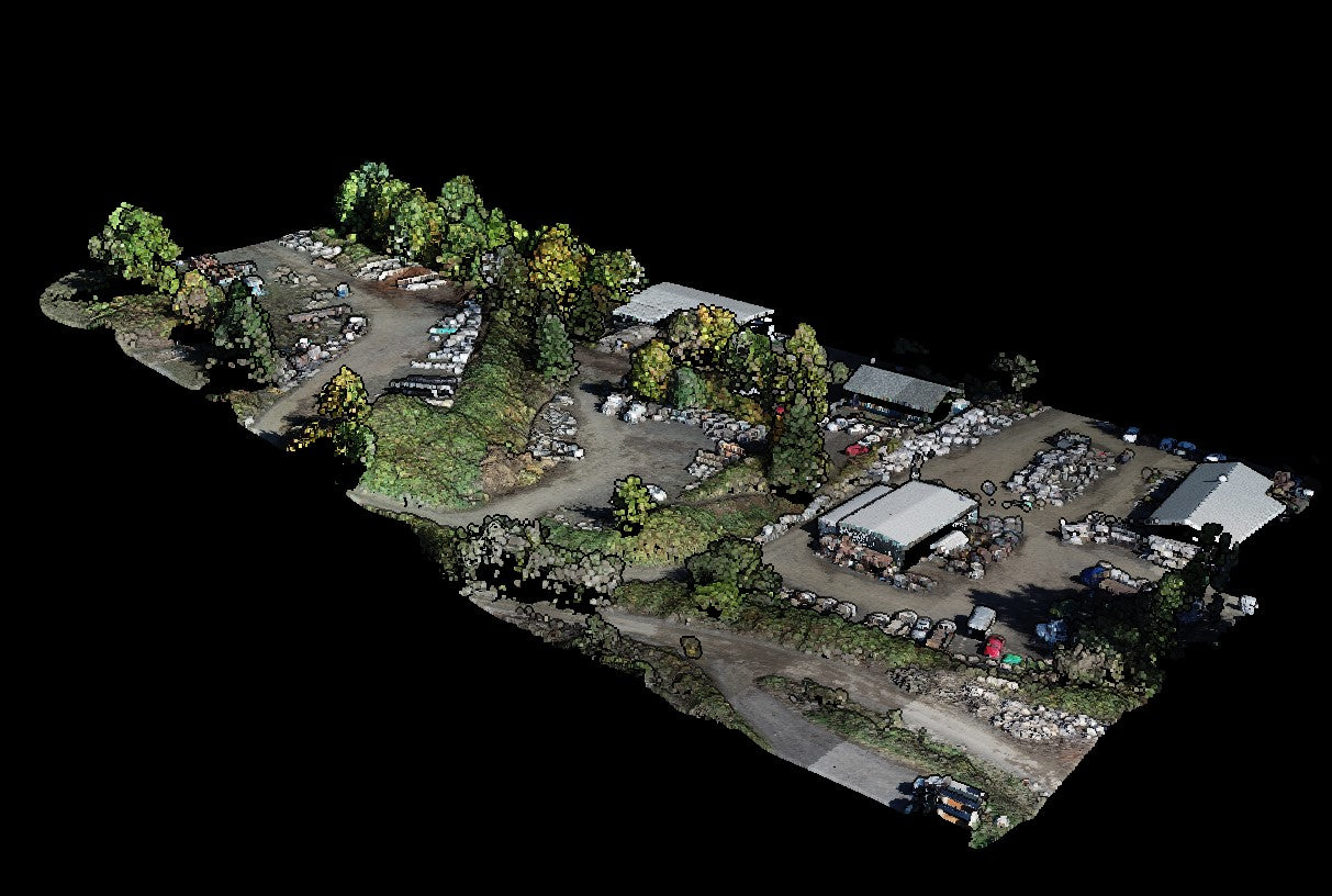
One of the most advanced applications of drone technology in real estate is photogrammetry, a technique that creates 3D property models and accurate topographic maps using drone-captured images. This allows agents and developers to provide buyers with detailed virtual representations of properties, ideal for large estates, commercial real estate, and vacant land sales. With photogrammetry, buyers can get an interactive and realistic view of a property’s layout, even without visiting in person.
Another cutting-edge tool in drone real estate marketing is RTK (Real-Time Kinematic) GPS technology. RTK-equipped drones provide extremely precise measurements of properties by correcting satellite positioning errors in real time. This level of accuracy is invaluable for real estate developers, surveyors, and investors who need precise property boundaries, elevation mapping, or site planning insights. Whether it’s measuring lot sizes or understanding land topography, RTK drone technology ensures precise, data-rich property overviews that standard aerial photography cannot match.
By incorporating advanced drone techniques like photogrammetry and RTK mapping, real estate professionals can offer more than just stunning visuals: they can provide accurate, data-driven insights that add value to property listings. Using this level of technology demonstrates expertise and a commitment to delivering the best possible experience for buyers and sellers, setting a brand apart in an increasingly competitive market.
Real Estate Drone Footage: The Future of Marketing

Incorporating real estate drone footage into property listings is a game-changer for real estate professionals looking to stand out in a competitive market. Aerial footage provides stunning visuals, comprehensive property overviews, and a high-tech edge that attracts more buyers and increases engagement. Whether it’s showcasing unique property features, providing a broader neighborhood perspective, or leveraging advanced drone technologies like photogrammetry and RTK mapping, drones offer a powerful way to elevate real estate marketing.
As buyers increasingly look for high-quality, immersive content, real estate agents and property developers who embrace drone technology position themselves as industry leaders. Investing in professional drone videography enhances credibility, improves listing performance, and ultimately helps properties sell faster. If you’re ready to take your real estate marketing to the next level, now is the time to harness the power of drone footage.